


New Garmin chartplotters first to offer built-in BlueChart® g3 with Navionics data
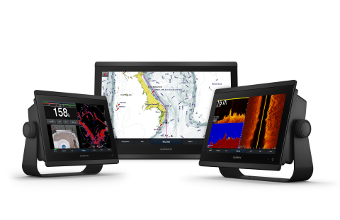
OLATHE, Kan. — (BUSINESS WIRE) — October 30, 2018 — Garmin International, Inc., a unit of Garmin Ltd. (NASDAQ: GRMN), today announced the GPSMAP 8600/8600xsv series, an extension of its flagship GPSMAP 8600 series that brings premium features like built-in sonar and new BlueChart g3 coastal cartography and LakeVü g3 maps with Navionics data and built-in Auto Guidance1 to smaller, more affordable display options. Available in 10-, 12- and 16-inch displays that feature full HD in-plane switching (IPS) screens with multi-touch control, the GPSMAP 8600/8600xsv series is Wi-Fi enabled and offers full connectivity and networkability so mariners can completely customize their marine electronics system based on their needs and preferences. The new GPSMAP 8600/8600xsv series is being announced at the 2018 Fort Lauderdale International Boat Show, and will be on display at the Garmin booth #332 in the electronics tent.
This press release features multimedia. View the full release here: https://www.businesswire.com/news/home/20181030005231/en/
Garmin® debuts GPSMAP® 8600/8600xsv series, expands its flagship line of all-in-one chartplotters with new sizes, built-in sonar and more (Photo: Business Wire)
“Garmin was the first to create a glass-helm design, and we’re excited to bring this stunning appearance to smaller, more affordable displays without compromising the premium performance our customers know and depend on from our award-winning GPSMAP series,” said Dan Bartel, Garmin worldwide vice president of consumer sales. “The GPSMAP 8600/8600xsv series offers unmatched sonar, cartography and connectivity capabilities so fishermen, cruisers and sailors can feel more confident at the helm, and spend more time enjoying their passions on the water.”
With built-in support for Garmin’s industry-leading sonar, the GPSMAP 8600xsv series includes support for dual-channel 1kW traditional CHIRP, CHIRP ClearVü and CHIRP SideVü scanning sonars, plus Ultra High-Definition scanning sonar, giving anglers the greatest sonar detail available from a Garmin system to date. These chartplotters also support the full Garmin Panoptix™ all-seeing sonar product line, including Panoptix LiveScope™, the first and only live real-time scanning sonar available on the market today. Transducers are sold separately. Non-sonar capable versions of each new display – the GPSMAP 8610, GPSMAP 8612 and GPSMAP 8616 – are also available.
The new GPSMAP 8600/8600xsv series is the first to come preloaded with Garmin’s exclusive BlueChart g3 coastal charts and LakeVü g3 inland maps with integrated Navionics data and Auto Guidance technology. This new Garmin cartography brings unrivaled detail and convenience to users by blending the best content from both Garmin and Navionics to provide navigational aids, spot soundings, depth contours, tides and currents, and detailed harbors and marinas. In addition, Garmin’s preloaded BlueChart g3 is the first to offer built-in Auto Guidance technology that instantly searches through relevant charts to create a suggested route based upon the dimensions of the user’s desired depth and overhead clearance. International versions of this new product line, the GPSMAP 8400/8400xsv series, are also available and come preloaded with a worldwide basemap.
For superior clarity and sunlight readability, the new GPSMAP 8600/8600xsv series offers full-HD IPS touchscreen displays that provide consistent, accurate colors that can be seen from all viewing angles, even with polarized sunglasses. The maximum glass design can be bail-, flush- or flat-mounted, enabling edge-to-edge installation of multiple displays.
The premium processing power found in the GPSMAP 8600/8600xsv series significantly benefits all onboard sensors like sonar, radar, cameras, video and digital switching, and enhances the user experience across the entire network. This lightning-fast processor also delivers Garmin’s fastest map drawing capabilities, so there’s hardly ever a delay, even at high speeds. With SmartMode, these multi-function displays (MFDs) are designed to give the user quick, one-touch access to the information they care most about. Users can configure and customize their entire system for activities ranging from docking, cruising, fishing, and anchoring with just one touch.
These powerful new MFDs are fully network capable with NMEA 2000 connectivity and the Garmin Marine Network to easily build a customized electronics suite – from sonar, radar and autopilots to instruments, cameras and multimedia. The screen can even be spilt to show up to six different features simultaneously, including HDMI video input. Sailors will also appreciate the built-in SailAssist feature that provides data, displays and prerace guidance needed to gain a competitive edge. For full control of the boat from the MFD, the GPSMAP 8600/8600xsv series also supports OneHelm™, an integrated solution that brings the power and convenience of controlling onboard boat systems like digital switching, lighting, stabilization and more, to the Garmin display.
The all-in-one compact design of the GPSMAP 8600/8600xsv series
eliminates the need for black-boxes, monitors, and external Wi-Fi
antennas. They feature built-in Bluetooth® connectivity, Wi-Fi®
and ANT® that allow the chartplotter to connect with
additional Garmin devices like a quatix™ 5 marine smartwatch, VIRB®
action cameras, or gWind™ Wireless 2 wind sensor. Users can also pair
the new GPSMAPs with the free ActiveCaptain® mobile app for
access to OneChart™, smart notifications, trip planning, software
updates and much more.


 Animation, 3D Art and 3D Models")