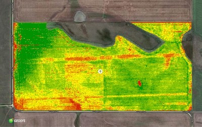
After conclusion of 2017 field trial pilot project, both companies look to expand their offering
PLYMOUTH, Minn., Jan. 25, 2018 — (PRNewswire) — Geosys and Textron Systems announce a successful demonstration of scientific-grade, high resolution aerial survey imagery to agribusinesses with a resolution as high as 3 centimeters per pixel. Each company brings 30 years of experience in its respective industry, providing the global agricultural sector with an unmatched legacy of service.
During the 2017 growing season, Geosys and Textron Systems successfully completed a multi-state project in the United States to digitalize field trials and production fields. The collaboration between the two companies will help address the needs for strip trials, high-value crops and small plots, in which high-resolution imagery provides value in precisely evaluating variability, up to the plant level. Because Textron Systems delivers processed multispectral orthoimagery, it can be integrated into Geosys' platform where it is cross-calibrated and used in conjunction with satellite imagery.
Geosys has been delivering remote sensing technology to agribusiness since its start in 1987. Through the development of its proprietary, source-agnostic image processing system, Geosys can acquire images from a variety of sources systematically to ensure a daily flow of data to its customers. The company has primarily focused on satellite imagery, which ranges from very low resolution (1 kilometer to 100 meters) to medium resolution (10 meters to 1 meter), but has recently been evaluating solutions for high resolution (1 meter to 1 centimeter).
"We have been actively looking for high-resolution imagery sources to enhance our decision support tools," said Dave Gebhardt, vice president of strategy at Geosys, "but most were unable to meet our expectations for scientific-grade data that could be cross-calibrated with satellite imagery on a global scale. Textron Systems met our enterprise needs and came with a proven track record of data delivery."
Textron Systems applies industry leading best practices for delivery of multispectral aerial imagery to customers – allowing for on-demand, next-day multispectral imagery service from acquisition to delivery. The application of best-in-breed sensors and best-in-breed software produced consistent high-quality imagery, which helped to ensure the 2017 growing season was both successful and efficient.
"Working closely with Geosys has provided a great deal of business value to our end users in agriculture," said Steve Mensh, electronic systems senior vice president and general manager at Textron Systems. "Geosys has the background and capabilities to turn pixels into actionable insights for agribusinesses, and we are equipped to help them bring high-resolution imagery to this industry."
Agribusinesses interested in learning more about the available services should contact sales.na@geosys.com.
About Geosys
Geosys is the first global digital agriculture company founded by agronomists. With 30 years of industry experience, Geosys provides clients with data, analysis and insights needed to make more informed decisions. Services range from worldwide risk management and monitoring agricultural commodities, to input sales and precision farming support by using the latest research in agronomics, information technologies and remote sensing. Geosys also develops highly customized business solutions for large, multinational agricultural companies. Acquired by Land O'Lakes, Inc. in 2013 as an independent business, Geosys is headquartered in Minneapolis, Minnesota with offices in France, Switzerland, Australia, and Brazil. For more information, visit www.geosys.com.

![]() View original content with multimedia:
http://www.prnewswire.com/news-releases/geosys-collaborates-with-textron-systems-to-bring-advanced-high-resolution-imagery-to-agribusiness-globally-300588028.html
View original content with multimedia:
http://www.prnewswire.com/news-releases/geosys-collaborates-with-textron-systems-to-bring-advanced-high-resolution-imagery-to-agribusiness-globally-300588028.html
SOURCE Geosys
| Contact: |
| Company Name: Geosys, Textron Systems
Emily Negrin, Geosys Email Contact 612-270-1186 Web: http://www.geosys.com |


