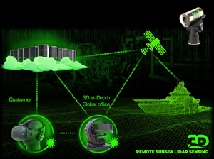
LONGMONT, Colo., June 23, 2020 (GLOBE NEWSWIRE) -- 3D at Depth Inc., the world’s leading expert in subsea laser (SL) LIDAR technology, survey support services, and 3D data solutions recently launched a remote sensing and remoted data control solution to help operators provide a safe, more efficient environment to their operations while increasing their near real-time 3D data intelligence. The remote sensing and remote data control technology is built around expanded capabilities originally embedded in 3D at Depth’s proven subsea LiDAR technology when the company first commercialized in 2014. With the onset of the COVID-19 pandemic, the recent downturn in the industry, and the race to advance autonomy into offshore oil and gas operations, 3D at Depth quickly phased in the technology as part of their current standard services.
In order to support the decision-making process across production and exploration, the technology development required design considerations from pre-project planning to data processing and control. The goal was to provide near real-time 3D data to help operators make a more informed quality decision to help balance the benefits and costs associated with subsea assets. With this approach, 3D at Depth developed software simulators that can be installed on the vessel prior to the start of any project to simulate a remote scan or metrology. An additional feature provides flexibility for those vessels with low bandwidth communications to shore. 3D at Depth’s Compressed Remote Command and Control solution enables full control with bandwidths of just 6kb/second, allowing data to be collected offshore and stored on the sensor or a topside computer. The near real-time data quality control is achieved using an improved and trusted enhancement of the RIAAT format and newly named, Compressed Range Intensity Angle Angle Time (cRIAAT). This improved feature enables moving a scan location with bandwidths of 256kb/second less than the collection time. This flexibility allows an onshore operator to receive data and start processing with little or no delays to the offshore operation. This approach can be utilized on many offshore applications including leak detection, static field scans, and metrologies.
The flexibility of third-party system incorporation, such as offshore connectivity allows for varying vessel specifications of ship-to-shore communications capabilities. The short base system is capable of running over a normal 4G network without delays. This allows a 3D at Depth Subsea LiDAR Specialist to collect from a customer’s worksite/location or from one of 3D at Depth’s global office locations. This is especially important during extreme weather events onshore or with complex secure locations where external or outside companies have restrictions on connecting to the client network.
A key added value of 3D at Depth's remote sensing and remote data control solution is the ability to collect offshore, then process and release onshore. The fast turnaround and shore-based Quality Control leverage the company’s resources and expertise across global time zones. From Houston, Texas, to Perth, Australia, and with our centrally located United Kingdom office, 3D at Depth delivers true global remote collection 24/7 without the extended working hours in any one office location.
“With 3D at Depth’s successful track record in applications such as asset inspection and integrity, leak detection and metrologies, and subsidence; our partners supported the idea of integrating remote sensing and remote data control into their projects,” stated Neil Manning, Chief Operational Officer at 3D at Depth. “Customers see real value in applications focused around seabed stabilization issues and offshore production expansion such as in brown or greenfield developments where touch-less metrologies are required. With positive early-stage results, we quickly realized this should be incorporated into our standard service package. The innovation started with the resident vehicle solution where in 2019 the company demonstrated this capability.”
3D at Depth’s remote sensing and remote data control solution also helps to reduce the risk of crewing offshore while providing additional benefits for today’s global restrictions on compliance requirements.
To date, the technology has been used for the movement of data and processing successfully in several projects in early 2020.
Oil and Gas Offshore’s podcast hosted by Andy Lash recently featured the market advantage of 3D at Depth’s technology in their podcast interview. Link Here. 3D at Depth Remote Sensing
For a brief overview on the benefits and applications of remote sensing and remote data technology, please visit 3D at Depth on YouTube direct link: https://youtu.be/-7F1GMr7MTk
Customer demonstrations are available on-demand to watch the remote sensing technology use cases in action. Please contact: Sales@3DatDepth.com
About 3D at Depth:
3D at Depth, Inc. provides advanced subsea LiDAR (SL) laser systems, survey support services, and 3D point cloud collection, visualization, and analysis solutions to help clients optimize marine, underwater and offshore survey campaigns. The precise, repeatable, millimetric 3D point clouds acquired through patented SL laser technology provides greater insight to measure, map, and evaluate underwater assets, resources, and environments. From data collection and processing, through visualization and analysis, clients can “measure in 3D and manage in 4D” to increase operational efficiencies and reduce downtime. The Company’s locations in Australia, Europe, and the United States support customer survey operations around the world. For more information and a broader listing of services visit us at
www.3datdepth.com and
LinkedIn, or follow us on Twitter @3DatDepth.
Media Contact:
3D at Depth:
Colleen Hahn
+1.703.851.6944
media@3datdepth.com
A photo accompanying this announcement is available at https://www.globenewswire.com/NewsRoom/AttachmentNg/4ec6deb0-14d2-4821-9738-535b7ab3a779


