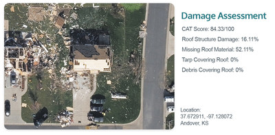
"This new capability helps our customers increase their knowledge on a property affected by wind and fire events, essentially changing the way they see and understand a storm's impact," shared Erik Jorgensen, CEO of Vexcel Group. "We've gone beyond what's discernible by the eye and helped uncover—through the application of machine learning—what's changed using our high-resolution post-CAT imagery. This in turn helps government agencies, insurers, and many others improve their response to impacted communities with faster, more reliable data showcasing property conditions."
Damage Assessment is part of Vexcel's Elements product line which uses machine learning (ML) to deliver rapid property insights. Providing this level of detail goes hand in hand with Vexcel's disaster imagery collection program (called Gray Sky), since its inception in 2017 with Hurricane Harvey in Texas. No one captures more disasters in the United States. And now Damage Assessment data can be automatically calculated and provided in a report shortly after imagery is published, so insurers can more efficiently and effectively respond to those impacted, without ever setting foot on the ground.
Faster Property Insights for Multiple Uses
A damage assessment of each property that falls inside a natural disaster impacted zone will be available to customers. These additional property insights can help multiple industries scale their responses to a disaster more appropriately or use the information to better prepare for future events.
- Insurance companies* can verify which policy holders have damaged property and begin the claims process immediately
- Emergency managers can locate the biggest debris obstructions on structures or property challenges as part of the recovery process
- Property assessors can identify changes on a property to update tax rolls in cases of extreme loss
- CAT/Risk modelers can analyze how a weather event moved through a community and identify what materials survived to plan for future disasters
Damage Assessment will be available through Vexcel's API and web-based application, Viewer, and will deliver an overall CAT score and FEMA classification estimate as well as specific information in percentages (0-100%) such as the degree to which debris covers a building, roof condition, missing roof material, and tarp coverage.
* Vexcel is the operations partner for the Geospatial Insurance Consortium (GIC), providing aerial imagery and data specifically packaged for insurers. Learn more at gic.org.
More Info
Vexcel collects the largest aerial program on the planet, delivering data at a resolution, clarity, and accuracy that's never been delivered on a global scale. Its robust library of geospatial data helps a variety of industries, such as Government, Telecom, Utilities, Insurance, AEC, Energy and more. Learn more about Vexcel's upcoming launch of Damage Assessment at
vexeldata.com/damage-assessment.
About Vexcel Data Program
For 30 years, Vexcel has been the industry leader in the photogrammetric and remote sensing space, providing a comprehensive library of cloud-based geospatial data. Vexcel's unique technology stack results in unrivaled image quality, helping customers streamline remote assessment, innovate common workflows, and enhance decision-making with confidence. Vexcel captures aerial imagery and geospatial data in 27 countries, including US, UK, Canada, Australia, Japan, and across Western Europe. More at
vexceldata.com.
![]() View original content to download multimedia:
https://www.prnewswire.com/news-releases/vexcel-to-provide-catastrophe-analytics-on-properties-after-major-weather-events-and-natural-disasters-301552526.html
View original content to download multimedia:
https://www.prnewswire.com/news-releases/vexcel-to-provide-catastrophe-analytics-on-properties-after-major-weather-events-and-natural-disasters-301552526.html
SOURCE Vexcel Data Program
| Contact: |
| Company Name: Vexcel Data Program
Kris Wagner Email Contact |


